Town History
We welcome anyone who is interested in our town to come visit.
Salyersville City Hall is open Monday-Friday from 8:00 AM - 4:00 PM.
Salyersville’s Wayfinding Signage Walking Tour
The City of Salyersville was fortunate to receive an ARC/Berea College Flex-E-Grant in 2016. Beautiful wayfinding signage throughout downtown was a major component of this grant. Items of interest pertain to both present and historic locations, buildings, and subjects.
Signs are numbered 1-10. A walking tour from sign to sign complete with a QR coded link to a website on each is being developed. Much more information about Salyersville’s rich history will be available upon its completion. Below is a very brief description of the subject matter for the signage. The subjects appearing on the signs are highlighted, italicized, and underlined.

Sign #1: Salyersville was incorporated in 1863
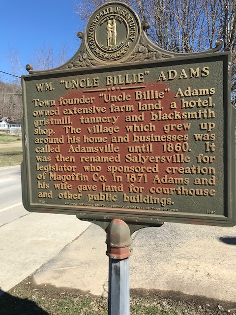
The town’s name was officially changed in honor of Kentucky Legislator Samuel Salyer. It was formerly known as Adamsville because William “Uncle Billy” Adams donated the land where present-day Salyersville sits. Magoffin County was formed in 1860 from parts of Floyd, Johnson, and Morgan Counties, mainly along the watershed of the Licking River. Beriah Magoffin of Harrodsburg was the governor at the time.
City Hall: The site where present-day Salyersville City Hall is located is also the Historic Tour Start.
Paintsville Lake-Jellico: One of the most rugged, scenic areas of Magoffin County lies 12 miles northeast of Salyersville and its topography is similar to the world-famous Red River Gorge area of Kentucky. Sandstone cliffs lead into a canyon that is now filled with water and beautiful Paintsville Lake. For directions, inquire in Salyersville City Hall (606) 349-2409.
Gardner Farm Homestead: The Gardner Farm Homestead was placed on the National Register of Historic Places in 2015. The focus for its placement was how it was a working farm during the antebellum period. This historic masterpiece retains many of the characteristics it had prior to the Civil War. Owner Benjamin Gardner is pleased to give tours. He can be reached at 606-349-6238.
Sign #2: Town Founder WM. “Uncle Billie” Adams
The places of interest denoted on signpost two, next to the red light downtown, are particularly interesting.
Church Street, so named for the Salyersville Christian Church that is built of locally harvested hand-hewn stone. Another is the magnificent, circa 1912, former Salyersville National Bank building (1912 SNB Building).
Both these, and another stone building line church street. Italian stone masons came to Salyersville around the turn of the century and constructed these masterpieces. Another subject of interest is the grave marker for the “Uncle Billie” Adams Grave located just off Church Street behind the Salyersville Christian Church.

1930’s Photo of “Old Salyersville National Bank Building”
Sign #3: In front of the Lloyd M. Hall Community Center
Sign 3 is in front of the Lloyd M. Hall Community Center by the Prater Memorial United Methodist Church. The Prater Memorial Methodist Church was constructed in 1925. This beautiful structure adds greatly to the historical ambiance and character of downtown.
The Lloyd M. Hall Community Center was completed in the 1970’s. It was named after a local prominent physician who practiced medicine in Salyersville for decades. Before the community center, this was the location of the Salyersville Grade School. The “old grade school” burned in the late 1960’s. Older citizens fondly remember it and its basketball gymnasium’s balcony down both sides.


Sign #4: Magoffin County Historical Society
Salyersville’s rich history can be explored at the Magoffin County Historical Society’s headquarters at South Church Street in downtown. Their collection of genealogical research, photos, and other historical information is the result of years upon years of research.
Another must-see is their large collection of relocated furnished early 19th century log houses and buildings. Signage denotes their origin, age, what family inhabited them, and other interesting facts.
Ramey Memorial Walk Bridge: This bridge connects the Lloyd M. Hall Community Center, downtown, to Ramey Park. This recent addition makes it very convenient to walk from downtown to the swimming pool in the middle of the park.
Sign #5: Prater’s Fort Cabins
As I mentioned earlier, the Magoffin County Historical Society has relocated and saved a huge collection of early 19th century log houses.
When one walks through and admires them, you must wonder about the families that inhabited them and the life of a bygone era.
Tours are available Monday through Friday.
The historical society can be reached at: 606-349-1607.

Sign #6: Dixie Subdivision:
The Dixie Subdivision has an interesting name. During the Civil War, Confederate troops camped on this knoll in a bend of the Licking River, hence the name “Dixie”.
It is also said Union troops camped on the other side of the river simultaneously at the Gardner Farm Homestead mentioned on Sign 1.
Ramey Memorial Park: Ramey Memorial Park is a spacious athletic focused park with baseball and softball fields, a swimming pool, tennis courts, walking track, playground equipment, and spacious picnic shelters for public events.
Magoffin Public Library: Magoffin County boast the most awe-inspiring state-of-the-art public libraries to be found anywhere in our area. It is brand new and is scheduled to have its grand-opening in June of 2019. Comprehensive service to the entire community is the goal of the Magoffin County Public Library as an institution.
Sign #7: Gardner Trail
From a historical standpoint, what the Gardner Trail has lost to history is a tragedy. In its heyday, the Gardner Estate along Ky Rt 7, was something to behold. A stone fence built by the same Italian stonemasons that constructed the 1912 Salyersville National Bank Building bordered the trail. Judge Ben Gardner’s massive mansion stood in the distance. There was a pond where ice skaters gathered in the winter. Ice for home use was cut from this pond and stored in a nearby icehouse for summer use.
Dawkins Line R to T- 8 Miles: The Dawkins begins just south of Paintsville in Johnson County; crosses Magoffin County near Salyersville passing through the official Kentucky Trail Town of Royalton and ends at Evanston in Breathitt County.
Residents of Salyersville treasure their proximity to the Dawkins. This scenic trail traverses three major river watersheds: The Big Sandy, Licking, and the North Fork of the Kentucky River. The Dawkins is a non-motorized multi-use trail catering to hikers, cyclists, and horseback riders. Highlights include beautiful scenery, abundant wildlife, 36 trestles, the 662’ long Ivyton Tunnel, and other points of interest. It is hoped the 1,556’ long Tip Top Tunnel will be made available for trail users in the not-too-distant future.
Royalton Kentucky Trail Town: Royalton Trail Town Incorporated is a non-profit organization located in Royalton, Kentucky. On October 9, 2015 Royalton, was certified as the 10th Trail Town in Kentucky. The Dawkins Rail Trail will be the longest rail trail in the State of Kentucky when phase three is completed. The Dawkins Rail Trail runs through the center of Royalton Trail Town. Huge things are in the works and funding has been secured for a campground, stage, restrooms, and rental cabins in Royalton.
Battle of Puncheon Civil War Park: The Battle of Puncheon Civil War Park is located eight miles south of Salyersville on KY Route 7. It has an annual reenactment, shelter, restrooms, walking track, and stage.
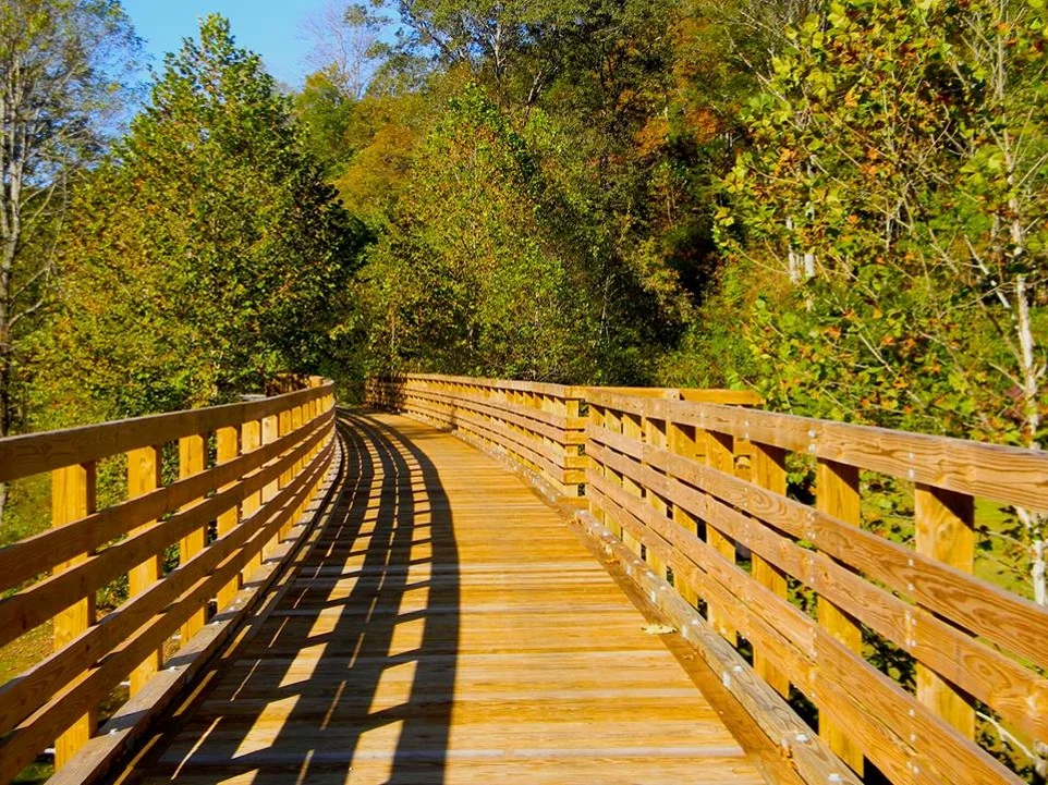
Trestle on the Dawkins Line Rail-to-Trail
Sign #8: Mural
The mural on the side of Prater Drug Store depicts buildings and images of historical significance from days past. “Jockey Lot” This area was so-named because it was an area where people would trade horses, particularly when circuit court was in session. “Jockies” would ride their mounts and demonstrate their gaits to perspective buyers.
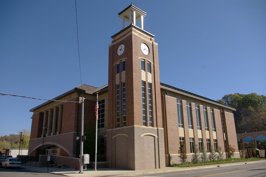
Magoffin County Justice Center
Sign #9: Justice Center
The Magoffin County Justice Center in an impressive building in the heart of downtown. It houses circuit, district, and family court. The Magoffin County Circuit Court Clerk’s office is also housed in this building.
Magoffin County Courthouse
Downtown Businesses: This is the heart of downtown Salyersville at the intersection of Church and Maple Streets.


Sign #10: Magoffin County Courthouse
The Magoffin County Courthouse houses offices for the Magoffin County Judge Executive, Magoffin Property Valuation Administrator, Magoffin County Court Clerk, Magoffin County Attorney, 911 system, and other public offices.
Magoffin Formed 1860: As mentioned earlier, Magoffin County was formed in 1860 and named after Governor Beriah Magoffin.